OK, here’s the story. Back down in the Borders for a couple of weeks, so I have to do at least one SOTA activation. Last year it was Blackwood hill, so something different this year. Having looked at the map and the SOTA database, I decided on Larriston Fell. First it looked easy enough, secondly after researching it I was intrigued by the mention of a mysterious carpark at the top of the forest track, and third it wouldn’t be much of a detour to visit another place that took my fancy – Bloody Bush – the old Border crossing between our Fair Nation and G land.
A couple of different maps can be used here – O/S explorers 324 and OL42 – as both have the desired track on them. During my research most of the info was on a South to North climbing of the hill, but I didn’t fancy driving round to Kielder to park the car and start there. Only one mention of an ascent from this side, and the person that wrote it suggested parking your car at the entrance to the track you will be walking, but this also leads up to a house on the track. I am a bit of a stickler for doing these things properly, so off I set the day before to find somewhere to abandon the SOTA waggon so it wouldn’t be in anyones way. The best, actually the ONLY parking spot was to be found about a half mile walk from the beginning of the track I would tackle where two cars can fit into the lay-by.
So, Saturday arrived and my alarm went off at half seven. I could just about hear the alarm over the noise of the rain drumming on the roof of the caravan, so it was quickly switched off and all thoughts of an early start soon disappeared as I drifted once more into the land of nod. Saturday afternoon turned out to be a cracker, so the day wasn’t wasted and the dogs enjoyed a good few miles on a forest track. I checked the WX for the morning. Sunday promised a good start with rain moving in later in the afternoon.
Sunday dawned bright with blue skies and very warm. I didn’t need to wait on my alarm getting me up, the sound of a heaving dog just about to be sick was the noise that welcomed me into the Sabbath. After cleaning up the mess, my good Lady wife reminded me that it was all MY fault this had happened as I had let him eat a big sheep pooh the day before – well he is a Labrador, and I didn’t exactly force it down his neck!! Once I had breakfasted and taken the dogs for a walk – avoiding all sheep shit this time, I was soon into the SOTA-mobile and on my way. My pack having been sorted on the Friday evening, all I had to do .") was get my chits out the fridge and stick them in. No Tesco petrol station around these parts to stock up on scran. It was a short drive of a few miles to NY53558 92716 where the motor was abandoned for the rest of the day. Ten minutes walking along the ‘main’ road
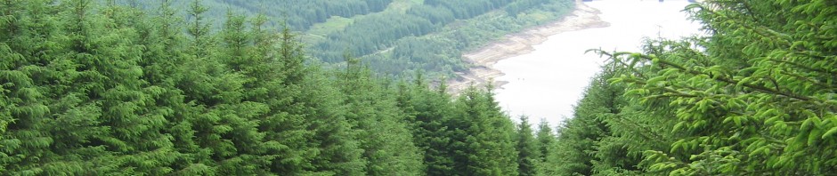
was get my chits out the fridge and stick them in. No Tesco petrol station around these parts to stock up on scran. It was a short drive of a few miles to NY53558 92716 where the motor was abandoned for the rest of the day. Ten minutes walking along the ‘main’ road  admiring the scenery had me at the start of the track at NY52914 92142. The gate has welcoming sign on it – PRIVATE ROAD – but as it is a forestry track also, I assumed this applies to motorized traffic only. Another ten minutes up this track and you are passing Mountain View which is a lovely looking cottage with a small stable etc – the kind of place we would all love to own. Just after this the forest thins out for a good bit and you are either walking in open space, or with the forest just on one side of you. Not a great deal to report on on this leg of the walk, just a constant up. Loads of very smart looking spider webs heavy with morning dew glistening in the sun, the odd deer could be heard in the forest and an occasional cry from a large bird were my companions on this part. As mentioned, plenty of going up. Do not deviate from the main path you are on, just keep going and you will leave the forest and arrive shortly thereafter at the mysterious car park on the hill. It took me about 1 hour 20 mins to cover the 3.44 miles to this point. As mentioned in a previous posting, I use Endomondo on my phone to log my walking, it is very accurate and is always to hand.
 The car park is like a large concrete oval on the top of the hill. It has been suggested it was used by the RAF, but I can’t find anything concrete (groan!) to support this. There are about 6 or 8 posts that look like cut off lamp posts which have heavy duty power points on them. I don’t know if they were used to supply vehicles that were parked up there, or maybe they were used to supply the near by radio tower from portable generators that might have been parked up before a mains supply was installed? Answers on a post card please if you can shed light on this. I didn’t look to see if the power points were male or female which might have provided a clue. Anyway, I’m off on one of my famous tangents. I stopped at this car park for something to eat and drink as I had pressed on pretty much without stopping since I got out the car. The midges were feasting on me too, but occasionally the breeze would pick up and offer welcome relief from them.
  Still just in a t-shirt, I had long trousers on for the first time this holiday as the reports had mentioned knee deep heather on the last push. Rummaging in my ruckie, I found my midge net which not only kept the wee buggers away, also acted as a kind of ‘kidnap’ hood and obscured my view of the way to go.
Once the flying pests had had their fill of me, I set off across the heather along an imaginary track shown on the O/S map. I crossed one low non barbed wire fence and headed to a high point. I was about half way to the trig. The heather had sphagnum moss to keep it company so watch where you step or you might end up with wet feet. It took  about half an hour to cross the moor to the trig. Once there, the breeze stayed reasonably constant so I could dispense with my netted headgear.
 The radio of choice for this outing was the FT817, coupled to a 3 ele ‘SOTA’ beam. Mounted on a short roach pole, the beam was about 8 feet off the ground. Coupled to my 512 meters ASL, I had not too bad a takeoff. Most of the surrounding terrain is a similar height so I wasn’t stuck immediately behind a big hill. A text alert from fellow activator and PARC club member Bobby GAX informed me Mr SOTA Robin PKT was about. I found him on his usual haunt of 145.400 and waited for him to finish his QSO. There was a bit of QSB, but signal reports of 5/1 were exchanged,
  not too shabby for a distance somewhere in the region of 216km or 134 miles! Happy to have my first STS in the bag, I QSY’d to .425 to try and get GAX. QSB allowing, we were 5/1 which was good as Bobby was not on the highest of hills in his area. Whilst not a SOTA STS, I was glad to get the contact with him as he had made the effort to head out to a high point and chase me. With signals fading, we bade each other 73 and I gave a few calls on S20. I could hear Robert 2M0IZC near Glasgow airport very clearly, but my efforts to contact him were thwarted. The next to come back to my call was Jim GM3JSX in Gretna. With a full scale signal, we had a short QSO then back on the hunt for my #4 to qualify the hill. Quickly I got 2E0MLY/m who was heading North on the M6 in his motor home. Next up was Peter G8RZ who was working lighthouses on the air with the other call sign of GB4WIL. Peter was on Walney Island in the club caravan for the weekend with others from his club activating the lighthouse.
I stopped for some scran, so I demolished the sandwiches lovingly prepared for me by my XYL – before she found out I had knocked the dog ill – and a bottle of Scotland’s finest IrnBru. There was a drop in the temperature and I could definitely see a grey mass approaching from the South West. Time for one last call before I packed the 817 safely out of harms way. Pointing North, I immediately had GM1TPO/m coming back to me. Rob was out walking in the Border hills with his XYL. We had an enjoyable QSO before we both decided it was time to leave our respective hills. With the prospect of the rain moving in as forecast, I packed up the 817 and then wrapped it in my bivvi bag as an extra measure. Once all ready to go, I heard a /p station on the VX7 handie. This was 2E0RWB/p. Ron was on the summit of G/LD-007 Fairfield. He had trouble logging my contact due to the heavy rain and was about to go QRT. This rubber stamped my idea to pack up and off I set.
Once back across the ‘moor’ at the radio mast, I decided that I would chance getting wet and head in the opposite direction to visit Bloody Bush. Still t-shirt clad, I set off at a decent pace and soon came to the border crossing. It was amazing to think that what was  now ‘in the middle of nowhere’ was once a main road and a principal crossing between Scotland and England. The very impressive stone pillar looks as good today as I’m sure it would have done when it was first built. No crap aluminum sign here, they knew how to make road signs back in the day. I amused myself with walking back
 and forward between Scotland and England for longer than was necessary, but as the rain was coming on, and it was time to head for home. I put on my trusty old North Face fleece which has been up many a mountain – not the best fitting or most stylish of garments, but it is an old friend of mine –
  and I set off back up the track to the car park in the sky before descending to my car parked in the valley below. The rain never progressed past the light shower stage and after 2 hours 3 minutes and 5.78 miles since leaving the summit I was back at the SOTA waggon which was waiting to shelter me from the rain.
Total milage for the day was 9.92, walking time was 3 hours 56 minutes and I managed a measly 7 contacts. An excellently enjoyable day, more contacts would have been good, but I had enough for the log. This is a grand walk and if ever the chance to be dropped off at the Newcastleton end and picked up again at the Keilder end presented itself, I would recommend it to anyone – well maybe not to my 80 year old parents but you get the idea.
So, onto my doggy forecast. Most of the time you are walking on a forest track which is shared with a cycle route, but I only came across 6 cyclists all day. So, if you are happy with this, then why not. The only time the dogs might need a hand is crossing the open moor with deep heather, but dogs being what they are I imagine all but the shortest legged of our hairy friends should manage to make their way across to the trig point. No sheep were encountered, but this is not to say they will never be there so an extendable lead or excellent close control of your pooch would be a help at times.

Ah, I completely missed you for a s2s, even though Bobby told me you’d be out, nevermind. I did this one from the Kielder side but still arrived at the concrete/mast complex just from the other-side. At least one of the widgets on the mast is used by the RAF range at Spadeadam which isn’t that far away, although whether the mast is theirs or they just borrow it from someone else I don’t know – half a useless fact for the day.
Thanks for the comment Iain, I am slightly wiser about the ‘mystery at the top of the hill’. Not a great deal of info about the hill on-line, hopefully someone can use this info for their hike to the top. Pity we missed the STS, we could have made it an annual event lol. Maybe next time. Roddy
Aye a cracking contact from the trig point above the B788..
Good to have got you on such a funny day signal wise…
Another unique chase.
Thanks.
Grand to make the contact, if the weather had stayed good a bit longer I might have managed a few of the others that were out that day too. Cheers for making the effort to chase me. The QSB was a bad but came and went with a regularity so it was a case of waiting a few minutes to make a dodgy contact come good. PS, my log is now in so you can claim the points 🙂
lol, just read this as I fell (excuse the pun) on this as I was browsing here I live … Been living here in our cottage at Larriston Rigg since 2016 in the middle of what was a ~1,600 acre farm that is now been planted up with ~2 million trees. I can see the mast from my living room window “though looking out just now its shrouded in low cloud, though not uncommon here 🙂 “. I’m lead to believe that the mast is also currently used for the emergency services as an electrician that visited me maintains the standby generator. I’ve met a few walkers passing through but never “yet” been up to the trig point or Blooody Bush myself but have been mowing some “walking” paths up through the new plantings towards the fell. The at the top of the planting is a waist height fence to protect it from wild goats that live out on Keilder. Just thought I’d comment as maybe some of the bleed through on either my walkii-talkies or home base CB may be one of you guys. Look forward to seeing you enjoy Larriston 🙂